

Evaluating Forest Disturbance Detection Methods based on Satellite Image Time Series for Amazon Deforestation Alerts
por Mota, F. B. D. S.1, Ferreira, K. R.1, and Escada, M. I. S1
1Instituto Nacional de Pesquisas Espaciais (INPE)
DOI: https://doi.org/10.5194/isprs-archives-XLVIII-3-2024-357-2024
Publisher: ISPRS | Publicado em: 7 de Novembro de 2024
© Author(s) 2024. This work is distributed under the Creative Commons Attribution 4.0 License.
Resumo
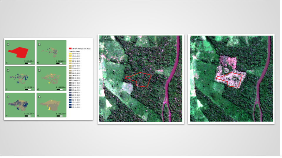
This study explores automated detection methods of forest disturbances using satellite image time series for Amazon deforestationalerts. The research focuses on two municipalities in southern Amazonas, Brazil, known for high numbers of deforestation alerts.Five methods—BFAST Monitor, CCDC, COLD, SCCD, and LSTM—were applied to Landsat image time series from 2017 to2020 to identify forest disturbances and their effectiveness were evaluated, by comparing their results with alerts from the BrazilianReal-time Deforestation Detection System (DETER). The results demonstrate that the COLD and SCCD methods achieved thehighest concordance rates with DETER alerts, at 82% and 85%, respectively, indicating their superior performance in disturbancedetection. The LSTM method also performed well, with an 83% concordance rate, showcasing the potential of deep learningtechniques in satellite image time series. The CCDC method followed with a 75% concordance rate, and the BFAST method hada concordance rate of 72%. This study highlights the importance of utilizing advanced modeling techniques and multi-spectralanalysis for effective forest disturbance detection. The results underscore the need for continued refinement and calibration of thesemethods to enhance their precision and reliability.
Keywords: Detecção de distúrbios, distúrbios florestais, dados de observação da Big Earth, séries temporais de imagens de satélite
Compartilhar e Citar
Mota, F. B. D. S., Ferreira, K. R., and Escada, M. I. S.: Evaluating Forest Disturbance Detection Methods based on Satellite Image Time Series for Amazon Deforestation Alerts, Int. Arch. Photogramm. Remote Sens. Spatial Inf. Sci., XLVIII-3-2024, 357–364, https://doi.org/10.5194/isprs-archives-XLVIII-3-2024-357-2024, 2024.