Slide 1

Produção, visualização e análise de grandes volumes de imagens de sensoriamento remoto modeladas como cubos de dados multidimensionais para todo o território brasileiro.

Slide 1

O Data Cube Explorer é um portal web para visualização de cubos de dados, coleções de imagens e classificações.

previous arrow
next arrow

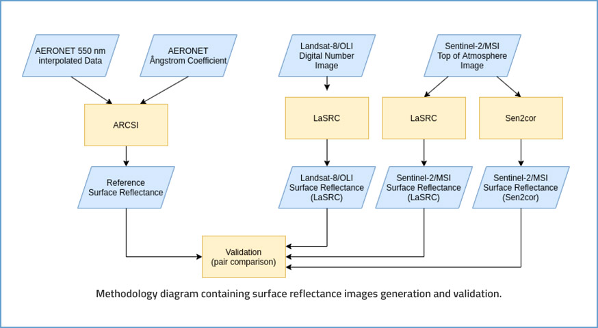
Evaluating the Impact of Lasrc and SEN2COR Atmospheric Correction Algorithms on LANDSAT-8/OLI and SENTINEL-2/MSI Data Over Aeronet Stations in Brazilian Territory

by R. F. B. Marujo¹, J. G. Fronza¹, A. R. Soares¹, G. R. Queiroz¹ and K. R. Ferreira¹ 1National Institute for Space Research (INPE), Brazil DOI: https://doi.org/10.5194/isprs-annals-V-3-2021-271-2021 Publisher: ISPRS | Published: 17 Jun 2021 © Author(s) 2021. This work is distributed under the Creative Commons Attribution 4.0 License. Abstract Accurate and consistent Surface Reflectance estimation from optical …

Quality control and class noise reduction of satellite image time series

by Lorena Alves Santos 1,*,Karine Ferreira 1,Michelle Picoli 1,Gilberto Camara 1, and Rolf E. O. Simoes¹ 1Earth Observation and Geoinformatics Division, National Institute for Space Research (INPE), Avenida dos Astronautas, 1758, Jardim da Granja, Sao Jose dos Campos, SP 12227-010, Brazil DOI: https://doi.org/10.1016/j.isprsjprs.2021.04.014 Publisher: ScienceDirect | Published: 15 May 2021 Abstract The extensive amount of Earth observation satellite images available brings opportunities …

Brazil Data Cube - 2019 - 2024