BIG Catalogue
STAC Collection - GOES-16 Cloud & Moisture Imagery
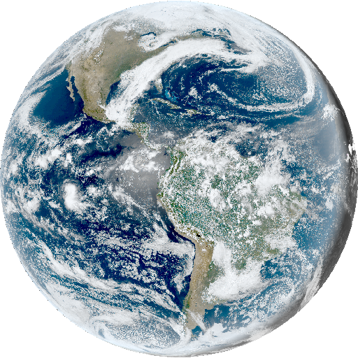
The GOES-16 Advanced Baseline Imager (ABI) L2 Cloud and Moisture Imagery provides 16 spectral bands with high temporal resolution over the American continent. The significance of the GOES-16 satellite for Brazil and South America lies in its location at longitude -75°, allowing it to offer comprehensive coverage of the continent and the oceanic regions of the Pacific and Atlantic. The ABI captures 2 visible, 4 near-infrared, and 10 infrared channels at resolutions ranging from 500m to 2km. This collection encompasses images acquired by the GOES-16 satellite (GOES-East) in full-disk mode, depicting nearly full coverage of the Western Hemisphere in a circular image. Important: note that other modes, such as CONUS and MESOSCALE, are not included in this collection. Cloud and Moisture Imagery product (CMIP) files are generated for each of the 16 ABI reflective and emissive bands. The collection captures CMIP product files into individual STAC Items for each observation from the GOES-16 satellite. It includes the original and full-resolution CMIP NetCDF files generated by INPE's GOES-R receive station. There is also a version for band 02, which originally has a resolution of 500m, degraded to 1km. For more information, refer to the Beginner’s Guide to GOES-R Series Data ( https://www.goesr.gov/downloads/resources/documents/Beginners_Guide_to_GOES-R_Series_Data.pdf), GOES-R Series Product Definition and Users Guide: Volume 5 (Level 2A+ Products) ( https://www.goes-r.gov/products/docs/PUG-L2+-vol5.pdf) and the ABI Bands Quick Information Guides ( https://www.goes-r.gov/mission/ABI-bands-quick-info.html).
Simple
- Date (Publication)
- Status
- On going
- Maintenance and update frequency
- Continual
- Keywords
-
-
goes
-
goes-16
-
level-2
-
cloud
-
moisture
-
meteorology
-
atmosphere
-
surface
-
brazil
-
- Access constraints
- Copyright
- Use constraints
- License
- Other constraints
-
Public Domain: https://www.nesdisia.noaa.gov/policy.html
- Spatial representation type
- Grid
- Metadata language
-
eng
- Character set
- UTF8
- Topic category
-
- Imagery base maps earth cover
- Begin date
- 2019-04-03
- End date
- 2025-04-07
))
- Reference system identifier
- UTM/WGS84
- Distribution format
-
-
JSON
PNG
NetCDF
(
)
-
JSON
PNG
NetCDF
(
)
- OnLine resource
-
INPE STAC Browser
(
WWW:LINK-1.0-http--link
)
This is the landing page for the INPE STAC server. The SpatioTemporal Asset Catalogs (STAC) provide a standardized way to expose collections of spatial temporal data. Here you will find collections of data provided by projects and areas of INPE.
- OnLine resource
-
GOES-16 Cloud & Moisture Imagery Collection
(
WWW:LINK-2.0-http--link
)
End point to access INPE Spatio Temporal Asset Catalog (STAC) server, collection GOES16-L2-CMI-1
- Hierarchy level
- Dataset
- File identifier
- GOES16-L2-CMI-1 XML
- Metadata language
- Portuguese
- Character set
- UTF8
- Date stamp
- 2024-10-21T18:21:11
- Metadata standard name
-
ISO 19115:2003/19139
- Metadata standard version
-
1.0
Overviews
Spatial extent
Provided by