BIG Catalogue
STAC Collection - GOES-13/Imager - Level-3 - VIS/IR Imagery (Binary)
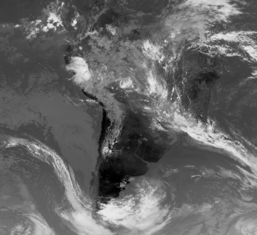
GOES-13 is a satellite of the Geostationary Operational Environmental Satellite (GOES) series operated by the National Oceanic and Atmospheric Administration (NOAA). Launched on May 24, 2006, it is designed to monitor weather conditions in North America, South America, and the Atlantic Ocean region. It operates in a geostationary orbit, meaning it remains fixed relative to Earth, continuously monitoring a specific region of the planet. In 2017, it was replaced by GOES-16 (GOES-East) as the primary operational weather satellite for the United States. Since then, it has been placed in a backup position. GOES-13/Imager instrument captures 1 visible and 4 infrared channels at resolutions of 1km (VIS) and 4km (IR). The collection captures product files into individual STAC Items for each observation from the GOES-13 satellite. It contains binary files in a grid format for each of the 5 spectral bands. The files are encoded using int16 and represent a matrix of values (reflectance for VIS and brightness temperature for IR) with 1714 lines and 1870 columns. Note: The values must be read as a one-dimensional array and then converted in memory to a two-dimensional m x n matrix. These versions are generated by INPE using the process of mapping data from the original geostationary projection to a uniform space-time geographic grid (EPSG:4326) with 0.04 degrees spatial resolution. The geographical area used in the remapping process was chosen because it covers and highlights Brazil, South and Central America. The image reprojection operation is performed using the gdalwarp utility ( https://gdal.org/programs/gdalwarp.html) with the nearest neighbor resampling strategy defined.
Simple
- Date (Publication)
- Status
- On going
- Maintenance and update frequency
- Continual
- Keywords
-
-
goes
-
goes-13
-
imager
-
level-3
-
cloud
-
meteorology
-
atmosphere
-
surface
-
brazil
-
- Access constraints
- Copyright
- Use constraints
- License
- Other constraints
-
Public Domain: https://www.nesdisia.noaa.gov/policy.html
- Spatial representation type
- Grid
- Metadata language
-
eng
- Character set
- UTF8
- Topic category
-
- Imagery base maps earth cover
- Begin date
- 2011-11-25
- End date
- 2018-01-08
))
- Reference system identifier
- UTM/WGS84
- Distribution format
-
-
JSON
Binary
PNG
(
)
-
JSON
Binary
PNG
(
)
- OnLine resource
-
INPE STAC Browser
(
WWW:LINK-1.0-http--link
)
This is the landing page for the INPE STAC server. The SpatioTemporal Asset Catalogs (STAC) provide a standardized way to expose collections of spatial temporal data. Here you will find collections of data provided by projects and areas of INPE.
- OnLine resource
-
GOES-13/Imager - Level-3 - VIS/IR Imagery (Binary) Collection
(
WWW:LINK-2.0-http--link
)
End point to access INPE Spatio Temporal Asset Catalog (STAC) server, collection GOES13-L3-IMAGER-1
- Hierarchy level
- Dataset
- File identifier
- GOES13-L3-IMAGER-1 XML
- Metadata language
- Portuguese
- Character set
- UTF8
- Date stamp
- 2024-10-21T18:21:11
- Metadata standard name
-
ISO 19115:2003/19139
- Metadata standard version
-
1.0
Overviews
Spatial extent
Provided by