 BIG Catalogue
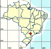
Estação de Ourinhos- Dados Radiométricos e Anemométricos 2007 - 2019
Latitude: 22° 56’ 55” S (-22,9486)
Longitude: 49° 53’ 39” O (-49,8942)
Altitude: 446
Fuso Horário: UTC -3
Tipo: ANEMOMÉTRICA
Observações: Declinação magnética local cresce 9’ ao ano.
* até 1979: 13° 20’
* para 2006: 18° 37’
Simple
- Date (Publication)
- Status
- Completed
Point of contact
INPE/MCTI
-
Rodrigo S. Costa
(
)
Av. dos Astronautas, 1758
,
São José dos Campos
,
Edifício DIIAV - Divisão de Impactos, Adaptação e Vulnerabilidades LABREN - 2° andar - sala 19
,
12227-010
,
Brasil
+55 12 3208-7908
Distributor
INPE/MCTI
-
SONDA - Sistema de Organização Nacional de Dados Ambientais
(
Function performed by the responsible party
)
Telephone number of a facsimile machine for the responsible organization or individual
Av. dos Astronautas, 1758
,
São José dos Campos
,
Edifício DIIAV - Divisão de Impactos, Adaptação e Vulnerabilidades LABREN - 2° andar - sala 19
,
12227-010
,
Brasil
Telephone number at which the organization or individual may be contacted
Telephone number of a facsimile machine for the responsible organization or individual
- Maintenance and update frequency
- Not planned
- Keywords
-
-
Dados Ambientais
-
Dados Radiométricos
-
Dados Meteorológicos
-
Ourinhos
-
Rede Sonda
-
Energia Renovável
-
Radiação Solar
-
DIIAV
-
Estação meteorológica
-
Anemometria
-
In-situ
-
São Paulo
-
- Keywords
-
- Access constraints
- License
- Use constraints
- otherRestictions
- Other constraints
-
Creative Commons - Atribuição-CompartilhaIgual 4.0 Internacional
- Spatial representation type
- Vector
- Metadata language
- Portuguese
- Character set
- UTF8
- Topic category
-
- Climatology, meteorology, atmosphere
- Begin date
- 2007-01-01
- End date
- 2019-04-30
N
S
E
W
))
- Reference system identifier
- EPSG:4674
- Distribution format
-
-
CSV
(
)
-
CSV
(
)
- OnLine resource
- Dados Anemométricos e Meteorológicos ( WWW:LINK-1.0-http--link )
- Hierarchy level
- Dataset
- File identifier
- 0709b0ef-b763-4470-b7a3-224382ee1044 XML
- Metadata language
- Portuguese
- Character set
- UTF8
- Date stamp
- 2025-09-17T14:28:48
- Metadata standard name
-
ISO 19115:2003/19139
- Metadata standard version
-
1.0
Point of contact
INPE/MCTI
-
Rodrigo S. Costa
(
)
Av. dos Astronautas, 1758
,
São José dos Campos
,
Edifício DIIAV - Divisão de Impactos, Adaptação e Vulnerabilidades LABREN - 2° andar - sala 19
,
12227-010
,
Brasil
+55 12 3208-7908
Point of contact
INPE/MCTI
-
SONDA - Sistema de Organização Nacional de Dados Ambientais
(
)
Av. dos Astronautas, 1758
,
São José dos Campos
,
Edifício DIIAV - Divisão de Impactos, Adaptação e Vulnerabilidades LABREN - 2° andar - sala 19
,
12227-010
,
Brasil
Overviews
Spatial extent
N
S
E
W
Provided by

Associated resources
Not available