 BIG Catalogue
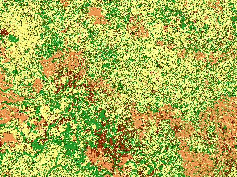
LCC CBERS-4 1M STK Mato Grosso - Natural, Semi-perenial Crop, Annual Crop and Pasture (Random Forest)
This land cover classification refers to a study area in Mato Grosso state, in the Cerrado biome. For this map, the CBERS-4/AWFI monthly data cube was used, with a spatial resolution of 64 meters, using the best pixel composition function (Stack). This experiment uses the time series of an agricultural calendar year, from September 2018 to August 2019, extracted from the CBERS-4/AWFI data cube. The classification was made using 852 samples (Annual Crop: 257; Natural Vegetation: 245; Pasture: 216; Semi-Perennial Crop: 134) and the following data cube bands: bands red, green, blue, and near-infrared along with the EVI, NDVI, GEMI, GNDVI, NDWI2, PVR indices applying the random forest algorithm. The classification quality assessment using 5-fold cross-validation (Wiens et al., 2008) of the training samples showed an overall accuracy of 97.0% and a Kappa index of 0.96. For more information see the paper "CBERS DATA CUBE: A POWERFUL TECHNOLOGY FOR MAPPING AND MONITORING BRAZILIAN BIOMES".
To access this resource in GeoTIFF format it is necessary to have an access key provided by the BDC-OAuth service.
Simple
Identification info
- Date (Publication)
- 2021-01-15
- Status
- Completed
- Theme
-
-
lcc
-
classification
-
data-cube-classification
-
data-cube-cbers4-wfi
-
Uso e cobertura da Terra
-
Mapa
-
DIOTG
-
BDC
-
CBERS-4
-
Mato Grosso
-
- Place
-
-
Brazil Mato Grosso State
-
Brazil
-
- Service Type
- COG-GeoTIFF Raster File
- Topic category
-
- Environment
))
- Coupling Type
- Tight
- OnLine resource
- LCC_C4_64_1M_STK_MT_RF_PA-SPC-AC-NA_v001_042050_2018-09-01_2019-08-31.tif ( FILE:RASTER )
- OnLine resource
- LCC_C4_64_1M_STK_MT_RF_PA-SPC-AC-NA ( OGC:WMS-1.3.0-http-get-map )
- File identifier
- 87a899b6-57cc-4d40-bab4-290fb5807208 XML
- Metadata language
- English
- Character set
- UTF8
- Hierarchy level
- Service
- Date stamp
- 2024-04-01T12:55:21
- Metadata standard name
-
ISO 19115:2003/19139
- Metadata standard version
-
1.0
Overviews
Spatial extent
Provided by