 BIG Catalogue
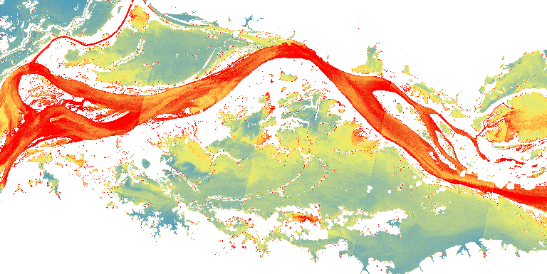
STAC Collection - KD - Curuai - S2 20m VisBands
Kd data generated based Semi-Analytical Algorithm developed by Maciel et al. (2020) ( https://doi.org/10.1016/j.isprsjprs.2020.10.009). The underwater light field modeling is essential for the understanding of biogeochemical processes, such as photosynthesis, carbon fluxes, and sediment transports in inland waters. Water-column light attenuation can be quantified by the diffuse attenuation coefficient of the downwelling irradiance (Kd). This dataset represents the Kd estimate for a Sentinel-2/MSI time-series at Curuai Lake region - Lower Amazon floodplains. This time-series data was generated for 66 Sentinel-2/MSI scenes (08/2015 to 09/2019) during the research paper titled Mapping of diffuse attenuation coefficient in optically complex waters of amazon floodplain lakes. This product was funded by the Brazilian Development Bank (BNDES), Fundação de Amparo à Pesquisa do Estado de São Paulo (FAPESP), Coordenação de Aperfeiçoamento de Pessoal de Nível Superior (CAPES), Conselho Nacional de Desenvolvimento Científico e Tecnológico (CNPq).
Simple
- Date (Publication)
- Status
- On going
- Maintenance and update frequency
- Continual
- Keywords
-
-
classification
-
sentinel
-
sentinel-2
-
thematic
-
cloud optimized geotiff
-
cog
-
diffuse attenuation
-
light attenuation
-
optically complex waters
-
neural networks
-
- Access constraints
- Copyright
- Use constraints
- License
- Other constraints
-
Creative-Commons-Attribution-4.0-International: https://creativecommons.org/licenses/by/4.0/
- Spatial representation type
- Grid
- Metadata language
-
eng
- Character set
- UTF8
- Topic category
-
- Imagery base maps earth cover
- Begin date
- 2015-08-19
- End date
- 2019-09-02
))
- Reference system identifier
- UTM/WGS84
- Distribution format
-
-
JSON
COG
PNG
(
)
-
JSON
COG
PNG
(
)
- OnLine resource
-
INPE STAC Browser
(
WWW:LINK-1.0-http--link
)
This is the landing page for the INPE STAC server. The SpatioTemporal Asset Catalogs (STAC) provide a standardized way to expose collections of spatial temporal data. Here you will find collections of data provided by projects and areas of INPE.
- OnLine resource
-
KD - Curuai - S2 20m VisBands Collection
(
WWW:LINK-2.0-http--link
)
End point to access INPE Spatio Temporal Asset Catalog (STAC) server, collection KD_S2_20M_VISBANDS_CURUAI-1
- Hierarchy level
- Dataset
- File identifier
- KD_S2_20M_VISBANDS_CURUAI-1 XML
- Metadata language
- Portuguese
- Character set
- UTF8
- Date stamp
- 2024-10-21T18:21:11
- Metadata standard name
-
ISO 19115:2003/19139
- Metadata standard version
-
1.0
Overviews
Spatial extent
Provided by
