 BIG Catalogue
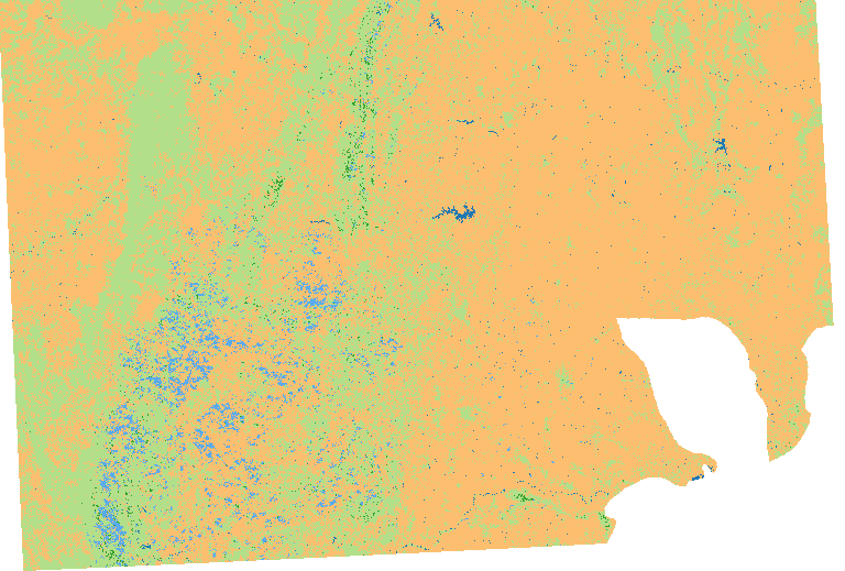
STAC Collection - LCC - Caatinga - LC8 30m 16D STK
This is a land cover classification map of Brazilian Caatinga, from January to December of 2017. This classification was made on top of Landsat-8 16 days data cubes with spatial resolution of 30 meters, using the best pixel composition function named as Least Cloud Cover First (LCF), which was previously named Stack in BDC older versions. The input datacube was Landsat-8 - OLI - Cube Stack 16 days - v001, which was deprecated. The classification model was trained using 9324 sample points of the classes Agriculture 172, Country formation 577, Forest (Formação florestal) 222, Savanna 4819, Pasture 3538. The spectral band used were B1, B2, B3, B4, B5, B6, B7, along with the vegetation indices EVI and NDVI; the clouded observation were identified using the Fmask algorithm and estimated using linear interpolation. The classification algorithm was Random Forest. The post-processing consisted on cropping the images to the biome's boundary. This product was funded by the Brazilian Development Bank (BNDES).
Simple
- Date (Publication)
- Status
- On going
- Maintenance and update frequency
- Continual
- Keywords
-
-
classification
-
landsat
-
landsat-8
-
thematic
-
cloud optimized geotiff
-
cog
-
earth observation
-
brazil
-
machine learning
-
random forest
-
land use/land cover classification
-
land use classes
-
- Access constraints
- Copyright
- Use constraints
- License
- Other constraints
-
Creative-Commons-Attribution-4.0-International: https://creativecommons.org/licenses/by/4.0/
- Spatial representation type
- Grid
- Metadata language
-
eng
- Character set
- UTF8
- Topic category
-
- Imagery base maps earth cover
- Begin date
- 2017-01-01
- End date
- 2019-12-31
))
- Reference system identifier
- UTM/WGS84
- Distribution format
-
-
JSON
COG
PNG
(
)
-
JSON
COG
PNG
(
)
- OnLine resource
-
INPE STAC Browser
(
WWW:LINK-1.0-http--link
)
This is the landing page for the INPE STAC server. The SpatioTemporal Asset Catalogs (STAC) provide a standardized way to expose collections of spatial temporal data. Here you will find collections of data provided by projects and areas of INPE.
- OnLine resource
-
LCC - Caatinga - LC8 30m 16D STK Collection
(
WWW:LINK-2.0-http--link
)
End point to access INPE Spatio Temporal Asset Catalog (STAC) server, collection LCC_L8_30_16D_STK_Caatinga-1
- Hierarchy level
- Dataset
- File identifier
- LCC_L8_30_16D_STK_Caatinga-1 XML
- Metadata language
- Portuguese
- Character set
- UTF8
- Date stamp
- 2024-10-21T18:21:11
- Metadata standard name
-
ISO 19115:2003/19139
- Metadata standard version
-
1.0
Overviews
Spatial extent
Provided by
