 BIG Catalogue
STAC Collection - MODIS-Aqua Monthly Rrs - OC-SMART AC
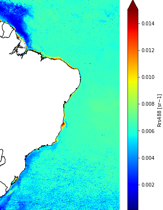
The MODIS-Aqua Monthly Remote Sensing Reflectance (Rrs, unit sr-1) provides 8 spectral bands temporal resolution of one month and spatial resolution of 1 km over the Brazil oceanic waters and open ocean South Atlantic waters. This collection captures 7 visible, and 1 infrared channels using Level-1A images acquired from the Moderate Resolution Imaging Spectroradiometer (MODIS) instrument onboard the NASA's Aqua satellite. The Level-1A data were processed into Level-1B and GEO using the Data Processing Tools (modis_L1B) from SeaWiFS Data Analysis System (SeaDAS) software. The Level-1B and GEO data were applied in the atmospheric correction OC-SMART (Fan et al., 2021) by the National Institute for Space Research (INPE, Brazil) and the Laboratoire d'Océanologie et de Géosciences (LOG, France) generating the Level-2 data. The Level-2 data has been mosaicked to generate daily maps capturing the complete Brazilian ocean waters. The daily mosaic data were reprojected to geographical (lat/lon) coordinates using as reference the European Space Agency (ESA) Ocean Colour - Climate Change Initiative (OC-CCI) into Level-3 grid. Both, the mosaic and the reprojection were done using the Sentinel Application Platform (SNAP) on its version 10. Finally, the daily reprojected data were temporal merged to create the monthly Rrs products using the geometric mean.
Simple
- Date (Publication)
- Status
- On going
- Maintenance and update frequency
- Continual
- Keywords
-
-
modis
-
aqua
-
level-3
-
rrs
-
reflectance
-
observation
-
monthly
-
surface
-
brazil
-
ocean
-
- Access constraints
- Copyright
- Use constraints
- License
- Other constraints
-
Creative Commons Zero (CC0): https://creativecommons.org/public-domain/cc0/
- Spatial representation type
- Grid
- Metadata language
-
eng
- Character set
- UTF8
- Topic category
-
- Imagery base maps earth cover
- Begin date
- 2002-07-04
- End date
- 2022-12-31
))
- Reference system identifier
- UTM/WGS84
- Distribution format
-
-
JSON
PNG
NetCDF
(
)
-
JSON
PNG
NetCDF
(
)
- OnLine resource
-
INPE STAC Browser
(
WWW:LINK-1.0-http--link
)
This is the landing page for the INPE STAC server. The SpatioTemporal Asset Catalogs (STAC) provide a standardized way to expose collections of spatial temporal data. Here you will find collections of data provided by projects and areas of INPE.
- OnLine resource
-
MODIS-Aqua Monthly Rrs - OC-SMART AC Collection
(
WWW:LINK-2.0-http--link
)
End point to access INPE Spatio Temporal Asset Catalog (STAC) server, collection MODISA-OCSMART-RRS-MONTHLY-1
- Hierarchy level
- Dataset
- File identifier
- MODISA-OCSMART-RRS-MONTHLY-1 XML
- Metadata language
- Portuguese
- Character set
- UTF8
- Date stamp
- 2024-10-21T18:21:11
- Metadata standard name
-
ISO 19115:2003/19139
- Metadata standard version
-
1.0
Overviews
Spatial extent
Provided by
