 BIG Catalogue
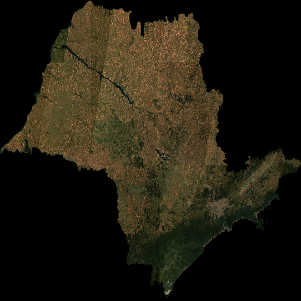
STAC Collection - Landsat Image Mosaic of São Paulo State - 6 months
Earth Observation Data Cube generated from Landsat Level-2 product over Sao Paulo State extension. This dataset is provided in Cloud Optimized GeoTIFF (COG) file format. The dataset is processed with 30 meters of spatial resolution, reprojected and cropped to BDC_MD grid Version 2 (BDC_MD V2), considering a temporal compositing function of 6 months using the Least Cloud Cover First (LCF) best pixel approach.
Simple
- Date (Publication)
- Status
- On going
- Maintenance and update frequency
- Continual
- Keywords
-
-
data cube
-
landsat
-
surface reflectance
-
vegetation index
-
cloud optimized geotiff
-
cog
-
earth observation
-
brazil
-
- Access constraints
- Copyright
- Use constraints
- License
- Other constraints
-
proprietary: https://www.usgs.gov/legal
- Spatial representation type
- Grid
- Metadata language
-
eng
- Character set
- UTF8
- Topic category
-
- Imagery base maps earth cover
- Begin date
- 2013-05-01
- End date
- 2023-10-31
))
- Reference system identifier
- UTM/WGS84
- Distribution format
-
-
JSON
COG
PNG
(
)
-
JSON
COG
PNG
(
)
- OnLine resource
-
INPE STAC Browser
(
WWW:LINK-1.0-http--link
)
This is the landing page for the INPE STAC server. The SpatioTemporal Asset Catalogs (STAC) provide a standardized way to expose collections of spatial temporal data. Here you will find collections of data provided by projects and areas of INPE.
- OnLine resource
-
Landsat Image Mosaic of São Paulo State - 6 months Collection
(
WWW:LINK-2.0-http--link
)
End point to access INPE Spatio Temporal Asset Catalog (STAC) server, collection mosaic-landsat-sp-6m-1
- Hierarchy level
- Dataset
- File identifier
- mosaic-landsat-sp-6m-1 XML
- Metadata language
- Portuguese
- Character set
- UTF8
- Date stamp
- 2024-10-21T18:21:11
- Metadata standard name
-
ISO 19115:2003/19139
- Metadata standard version
-
1.0
Overviews
Spatial extent
Provided by
