Brazil Data Cube project activity report – January 2020 to May 2021
by Abner Ernani dos Anjos, Alana Kasahara Neves, Alber Hamersson Sánchez Ipia, Carlos Alberto Ferreira de Noronha, Claudinei de Camargo, Fabiana Zioti, Felipe Carvalho de Souza, Felipe Menino Carlos, Gabriel Sansigolo, Gilberto Ribeiro de Queiroz, Jeferson de Souza Arcanjo, Karine Reis Ferreira Gomes, Lorena Alves dos Santos, Luciana Mamede dos Santos, Raphael Willian da Costa, Rennan de Freitas Bezerra Marujo, Rolf Ezequiel de Oliveira Simões
National Institute for Space Research (INPE), Avenida dos Astronautas, 1758, Jardim da Granja, Sao Jose dos Campos, SP 12227-010, Brazil
DOI – https://doi.org/10.52169/iiyj1825
Publisher: Inpe | Published: 20 December 2021
The Brazil Data Cube project is part of the “Environmental Monitoring of Brazilian Biomes project“, funded by the Amazon Fund through the financial collaboration of the Brazilian Development Bank (BNDES) and the Foundation for Science, Technology and Space Applications (FUNCATE) no. 17.2.0536.1. Brazil Data Cube is the successor of the research project e-sensing, funded by FAPESP (Fapesp 2014/08398-6).
Introdução
This report describes the activities performed and all data, software and classification products generated by the Brazil Data Cube (BDC) project team, from January 2020 to May 2021. This is a subproject of the Environmental Monitoring of Brazilian Biomes project, financed with resources from the Amazon Fund, through the financial collaboration BNDES and FUNCATE nº 17.2.0536.1.
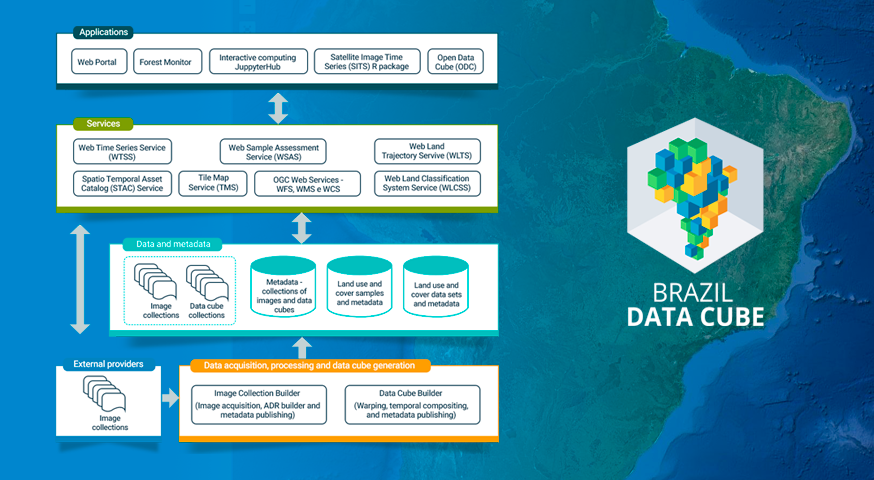
During this period, the BDC project team continued the development and evolution of the computational platform modules, illustrated in Figure 1, as well as the production of collections, data cubes and mosaics from remote sensing images. Based on big data technologies and web services for geographic data, computational tools were developed for the generation and consumption of medium spatial resolution image data cubes.
During this period, the collections and data cubes of MODIS, CBERS-4/4A, Landsat-8 and Sentinel-2 images were expanded to reach the goal of covering the entire national territory and including recent images. In addition, mosaics of CBERS-4 and Landsat-8 images were created for all of Brazil. The BDC platform family of systems and services continued to grow, with improvements and new implementations in Image Collection Builder and Cube Builder software, integration of BDC products with the Open Data Cube framework, updating of BDC Explorer, maturation of WTSS and WLTS services, creation of interactive environments for application development and application evolution, such as SITS, among many other advances.
*The report is only available in Portuguese.
© Esta obra foi licenciada sob uma Licença Creative Commons Atribuição-NãoComercial 3.0 Não Adaptada.


