Slide 1

Production, visualization and analysis of large volumes of remote sensing images modeled as multidimensional data cubes for the entire Brazilian territory.

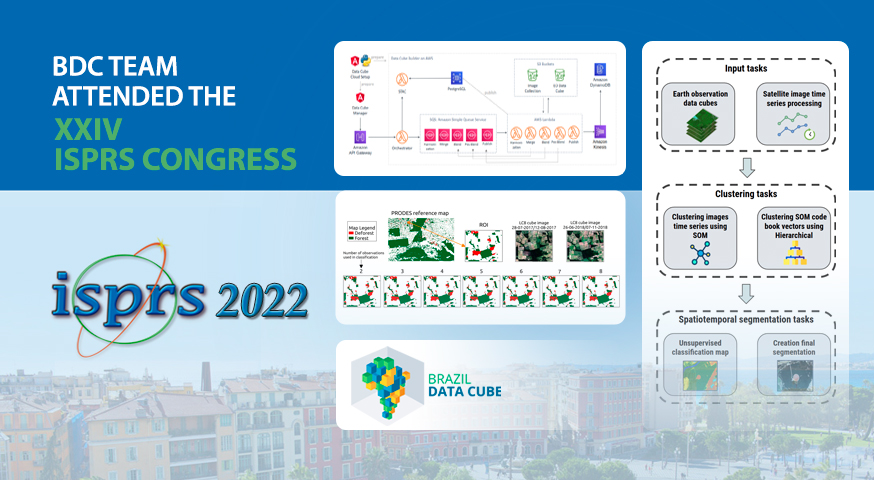
BDC team attended the XXIV ISPRS Congress 2022 last week presenting three papers

The BDC team attended the International Society for Photogrammetry and Remote Sensing Congress (XXIV ISPRS 2022), presenting three papers. The first paper “Building Earth Observation Data Cubes on AWS” describes an application for building EO data cubes on the Amazon Web Service (AWS) cloud computing environment. The second paper “Spatiotemporal Segmentation of Satellite Image Time …

Participate in the demonstration of the data and software products of the BDC project in the Workshop “Agro: Technologies and Spatial Applications”

The Brazil Data Cube project team will demonstrate their data and software products at the Workshop “Agro: Technologies and Space Applications” and will take place on May 24, 2022, at the SENAI Events Center Cuiabá, MT, with an opening ceremony scheduled for 8:00 am. The event is idealized by the Brazilian Space Agency and organized …

The BDC team will attend the Workshop for the GEO Wetlands Initiative

The Brazil Data Cube and SABERES project teams will present their joint initiatives to produce Sentinel 1 data cubes and to extract water bodies from them using machine learning at Virtual Ideation Workshop for the GEO Wetlands Initiative, tomorrow, May 11, 2022. The event is organized by the Group on Earth Observations (GEO), an international …

The BDC team presents the results in using the AWS computing environment to process big Earth observation data

The BDC team will present the results in using the AWS computing environment to process big Earth observation data in the session “Share lessons learned from the effort to democratize access to Earth Observations and computing environments for developing countries in support of sustainable development” in the GEO-AWS EO Cloud Credits side-event of the GEO …

Presentation today on the BDC project at the 6th Scientific Day of Geography UNIFAL-MG.

O projeto BDC será apresentado hoje, 10 de novembro, às 19:00, na mesa redonda sobre “Avanços geotecnológicos como suporte à análise geográfica”. O evento terá transmissão via canal do youtube do Programa de Pós-Graduação em Geografia (PPGEO/UNIFAL). Neste ano, a 6ª Jornada Científica da Geografia terá como tema “O conhecimento geográfico na interpretação do mundo …

BDC team will attend FOSS4G 2021’s Indigenous Hackathon by GEO

On October 1-2, 2021, the BDC team will attend the Indigenous Hackathon by the Group on Earth Observations (GEO). A hackathon by and for Indigenous communities, at FOSS4G (Free and Open Source Software for Geospatial) 2021 conference. The FOSS4G conference is the premier international event dedicated to presenting new developments in open-source software for geospatial …

Brazil Data Cube team will attend the GISFOREST Workshop

The BDC team will present the project in the International Workshop on Forest Geotechnologies (GISFOREST), on September 1st. GISFOREST is an event of innovations in geotechnologies for forest applications. This is the second edition and will take place online, from August 31st to September 2nd. The registrations can be made on the event website. Source: …

Brazil Data Cube team will attend the MundoGEO Connect

The Brazil Data Cube team will attend the MundoGEO Connect event, tomorrow, August 19th, at 2 pm. The lecture about the project will be in the panel: Images, Artificial Intelligence, Machine and Deep Learning, with the theme: “Brazil Data Cube Project: Image data cubes, big data, time series analysis and machine learning”. The event is …

BDC team will attend the IGARSS-2021 Symposium this week

The BDC team will attend on July 13th the International Geoscience and Remote Sensing Symposium (IGARSS-2021) presenting the paper “RSTAC: An R package to access spatiotemporal asset catalog satellite imagery”. The package provides functions to access, search and download spacetime earth observation data via STAC and is published in the CRAN.’ The paper and presentation will be …

Live demonstration of SITS with SEPAL platform in the GEO-GFOI Workshop

The BDC team will present tomorrow (June, 16th) in the GEO-GFOI Workshop a live demonstration of the R package SITS (Satellite Image Time Series Analysis) running in the SEPAL platform. SITS is an open source R package for satellite image time series analysis and machine learning. It supports the complete cycle of data analysis for …

Brazil Data Cube - 2019 - 2024