
Using time series and machine learning techniques to classify agricultural areas in petrolina-pe
by BRITO, Pedro1; CARVALHO, Herica2; CHAVES, Michel3; SANTOS, Rafael1
1National Institute for Space Research (INPE)
2Renato Archer Information Technology Center
3Universidade Estadual Paulista “Júlio de Mesquita Filho” (UNESP)
XXI Brazilian Remote Sensing Symposium: https://proceedings.science/sbsr-2025/trabalhos/uso-de-series-temporais-e-tecnicas-de-machine-learning-para-classificar-areas-ag
Publisher: Proceedings XXI Brazilian Remote Sensing Symposium | Published on 13 April 2025
Abstract
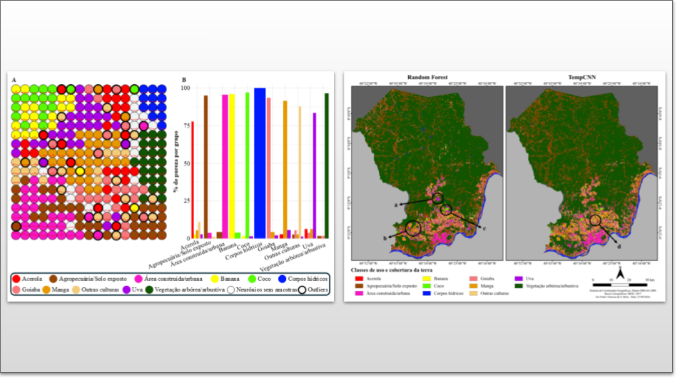
The objective of this study was to evaluate the use of satellite image bands to map agricultural areas in Petrolina-PE, utilizing time series and machine learning algorithms. The Random Forest (RF) and Temporal Convolutional Neural Network (TempCNN) models were compared in identifying land use and cover classes, with an emphasis on agricultural crops that are economically important to the region. Sentinel2 images were organized into data cubes, and samples were collected to train the classifiers and validate the maps. Both models performed well in distinguishing the classes, with RF excelling in some specific classes, while TempCNN achieved higher overall accuracy, demonstrating robustness for largescale mapping of agricultural areas.
Keywords: Machine Learning, Data cubes, Agricultural crops
Share and Cite
BRITO, Pedro et al. USO DE SÉRIES TEMPORAIS E TÉCNICAS DE MACHINE LEARNING PARA CLASSIFICAR ÁREAS AGRÍCOLAS EM PETROLINA-PE. In: Proceedings XXI Brazilian Remote Sensing Symposium, 2025, Salvador. Galoá, 2025. Available in: <https://proceedings.science/sbsr-2025/trabalhos/uso-de-series-temporais-e-tecnicas-de-machine-learning-para-classificar-areas-ag?lang=pt-br> Access: 2025, May 21th.