
WTSS-QGIS: an extension for retrieving and visualizing satellite image time series in the QGIS environment
by ANJOS, Abner1; VIEIRA, Fabiana Zioti1; COSTA, Raphael Willian da1; QUEIROZ, Gilberto Ribeiro de1; FERREIRA, Karine Reis1; CHO, David Fernando1.
1National Institute for Space Research (INPE)
XXI Brazilian Remote Sensing Symposium: https://proceedings.science/sbsr-2025/trabalhos/wtss-qgis-uma-extensao-para-recuperacao-e-visualizacao-de-series-temporais-de-im
Publisher: Proceedings XXI Brazilian Remote Sensing Symposium | Published on 13 April 2025
Abstract
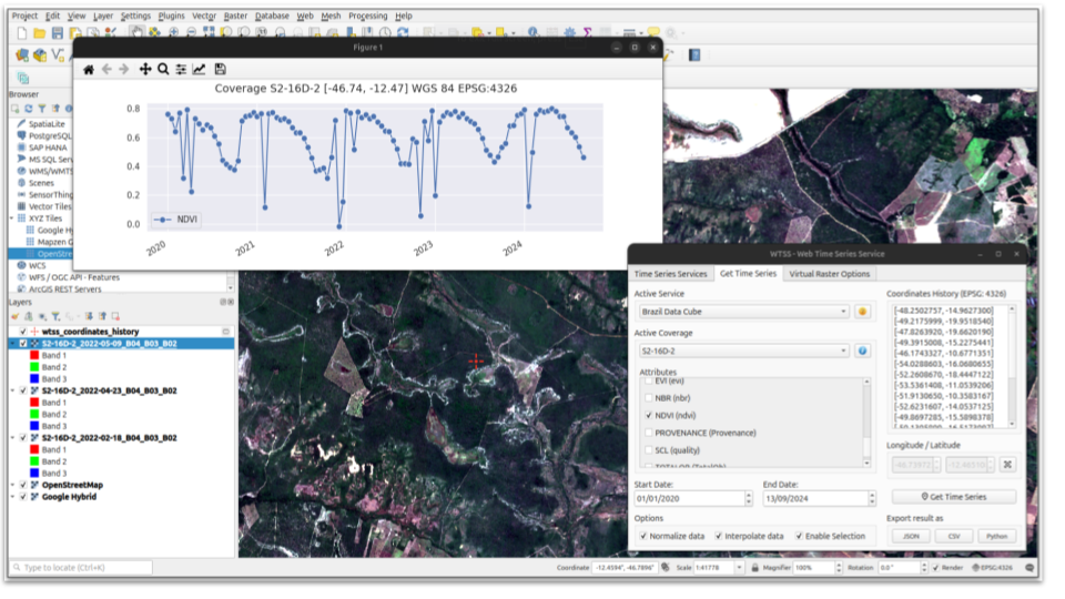
This article describes the development of a plugin for retrieving time series from remote sensing images in the QGIS environment. The plugin makes use of the Web Time Series Service (WTSS), produced by the Brazil Data Cube project, which enables simple and effective representation for time series data. The main objective of this plugin is to facilitate and optimize the accessibility of the WTSS service by offering users a graphical interface connected directly to the QGIS environment. In this way, it reduces the effort involved in commands, routines and scripts in retrieving and formatting a massive set of time series, allowing extensive analysis of a study area, without requiring users to have specific technical programming knowledge.
Keywords: Earth Observation Data, geotechnologies, geoservices, Data Cube, Temporal Data Analysis
Share and Cite
ANJOS, Abner et al. WTSS-QGIS: uma extensão para recuperação e visualização de séries temporais de imagens de satélite no ambiente QGIS. In: Proceedings XXI Brazilian Remote Sensing Symposium, 2025, Salvador. Galoá, 2025. Available in: <https://proceedings.science/sbsr-2025/trabalhos/wtss-qgis-uma-extensao-para-recuperacao-e-visualizacao-de-series-temporais-de-im?lang=pt-br> Access: 2025, May 5th.