
Mapping of forest disturbances in the state of Maranhão using time series and data cubes
by Wesley Augusto Campanharo 1 Celso H. L. Silva-Junior 2 Mateus de Souza Macul 1 Karine Ferreira 1 Gilberto Ribeiro de Queiroz 1
¹ National Institute for Space Research (INPE), Avenida dos Astronautas, 1758, Jardim da Granja, Sao Jose dos Campos, SP 12227-010, Brazil
2 University of California Los Angeles – UCLA
Anais / Proceedings XX SBSR – Vol 20, 2023. – 156008: https://proceedings.science/sbsr-2023/trabalhos/mapeamento-de-disturbios-florestais-no-estado-do-maranhao-por-meio-de-series-tem?lang=pt-br
Publisher: SBSR | Published: April 5, 2023
Abstract
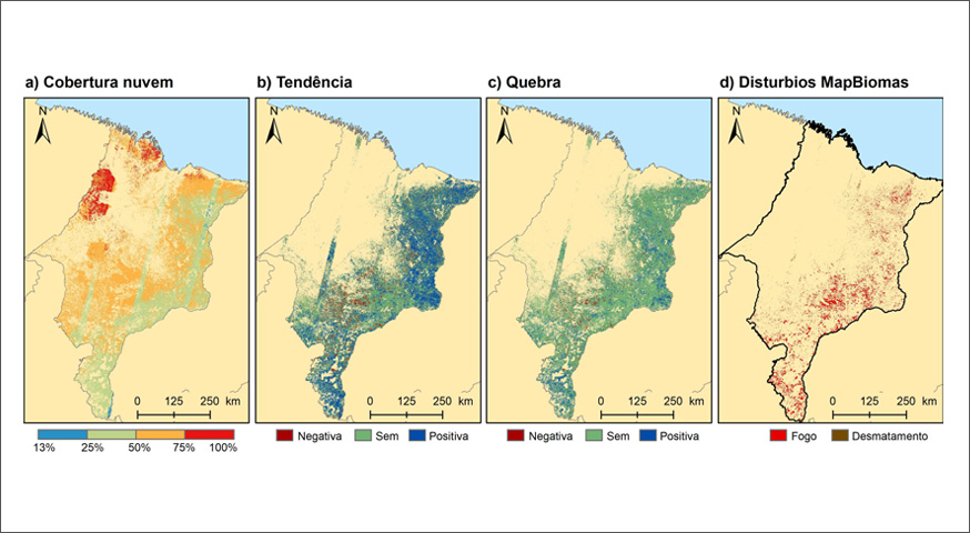
The use of time series in the detection of more complex forest disturbances has gained relevance recently. The BFAST is one of the models developed to capture these changes,
indicating breaks and trends. Thus, we aim to identify disturbances in forest areas during 2020, considering their behavior between 2016 and 2019. For this, we use NDVI time series derived from Landsat imagery provided by the BDC, and the BFAST_monitor algorithm, using the state of Maranhão as a study area. Of the total monitored (127,072 km²), 36,521 km² were identified with some type of disturbance, of this total about 15% are in vulnerable areas (with a decline in trend), 35% in areas without trend and 50% in areas with growth. The area mapped with disturbance is considered small, once the model presented low user accuracy for the determination of disturbances, showing that many of the disturbances were not correctly classified.
Keywords: BFAST, time-series, Fires, Deforestation, Degradation
© This is an open access article distributed under the Creative Commons Attribution License which permits unrestricted use, distribution, and reproduction in any medium, provided the original work is properly cited