
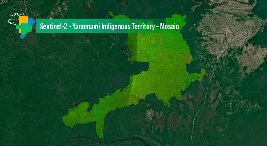
Sentinel-2 image Mosaic of Brazilian Yanomami Indigenous Territory – 6 Months
by BDC Team
National Institute for Space Research (INPE), São José dos Campos 12227-010, Brazil
DOI – https://doi.org/10.52169/WRHT9096
Publisher: Inpe | Published: May 2023
Overview
An image mosaic of the Sentinel-2 images covering the Brazilian Yanomami Indigenous territory. It was created from a Sentinel-2 data cube, with 10 meters of spatial resolution images, 6 months of temporal step (from April to September and from October to March), from 2019 until 2022, using the Least Cloud Cover First (LCF) composition strategy.
Data Access
The Mosaic Mosaic Sentinel-2 – Yanomami can be accessed through the Brazil Data Cube portal and also through GIS applications through the OGC WMS service, using the following address:
https://data.inpe.br/bdc/geoserver/mosaics/ows
(Choose layer mosaic-s2-yanomami_territory-6m)
Additional information
| Temporal Coverage | Start Date: 01/04/2019 End Date: 01/04/2022 |
| Coverage | West-bound Longitude: -66.7653226043403 South-bound Latitude: -0.90445660547424 East-bound Longitude: -60.9773018824126 North-bound Latitude: 4.94322243048352 |
| Instruments | MSI |
| Platform | SENTINEL-2 |
| Sources | Sentinel-2 – MSI – Sen2cor – Cube LCF 16 days – v002 |
© Esta obra foi licenciada sob uma Licença Creative Commons Atribuição-NãoComercial 3.0 Não Adaptada.