Use of time series for land use and land cover classifications in Petrolina, Pernambuco
by Pedro Brito 1 Michel Chaves 1 Herica Carvalho 2 Felipe Souza 1 Baggio Silva 1 Karine Ferreira 1 Rafael Santos 1 Gilberto Ribeiro de Queiroz 1
¹ Instituto Nacional de Pesquisas Espaciais, Avenida dos Astronautas, 1758, Jardim da Granja, Sao Jose dos Campos, SP 12227-010, Brasil
2 Universidade Federal de Pernambuco – UFPE
Anais / Proceedings XX SBSR – Vol 20, 2023. – 156223: https://proceedings.science/sbsr-2023/trabalhos/uso-de-series-temporais-para-classificacoes-de-uso-e-cobertura-da-terra-em-petro?lang=pt-br
Publisher: SBSR | Published: April 5, 2023
Resumo
The wide range of freely available satellite images and advances in computational methods have promoted the use of remote sensing techniques to analyze the Earth’s surface, improving analysis of vegetation. In regions such as the semi-arid zone of the Caatinga biome, this has been essential to assess the conditions and seasonality characteristic of
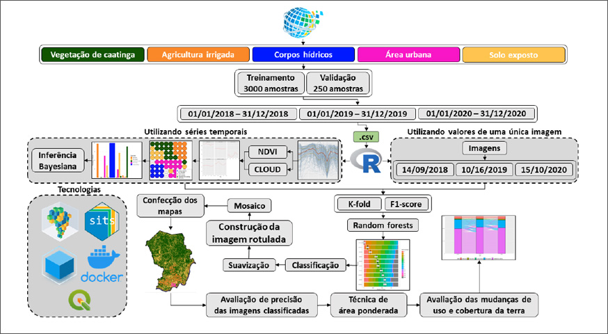
the local vegetation. The objective of this study was to generate land use and land cover classifications and assess changes between 2018 and 2020 through two approaches:
(1) classification of satellite image time series and (2) classification of each satellite image individually. This study concludes that the first approach using the Randon Forest method and NDVI time series enhanced the differentiation of land use and land cover classes in Petrolina-PE. View Full-Text
Keywords: Random Forest, Data cubes, Temporal analysis.
© This is an open access article distributed under the Creative Commons Attribution License which permits unrestricted use, distribution, and reproduction in any medium, provided the original work is properly cited


