
Deter
Daily Monitoring of Native Vegetation Suppression and Degradation
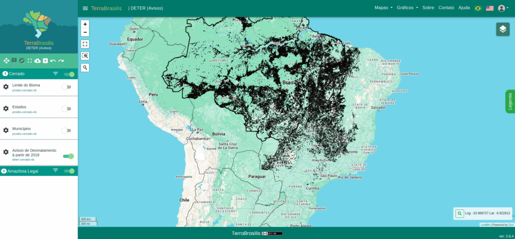
Deter is INPE’s daily remote sensing monitoring system that identifies evidence of native vegetation suppression or degradation in Brazilian biomes. It produces alerts on native vegetation suppression and forest degradation in the Brazilian Legal Amazon, and on native vegetation suppression in the Cerrado and Pantanal biomes and in Non-Forest areas1 na Amazônia.
Created in 2004, the Deter system was developed as an alert system to support enforcement and control efforts to combat deforestation and forest degradation by the Brazilian Institute of Environment and Renewable Natural Resources (IBAMA) and State Environmental Agencies.
Alerts
Alerts indicate locations of complete native vegetation suppression — associated with clear-cutting, mining, and exposed soil with vegetation — and locations of forest degradation resulting from selective logging, fires, and other practices that partially alter native vegetation cover.

Currently, Deter uses images from the Brazilian satellites Amazônia 1, CBERS 4, and CBERS 4A (Wide Field Imaging sensor – WFI camera), and maps alerts with a minimum area of 3 hectares.
Deter Classes
The deforestation process occurs through clear-cutting, when vegetation cover is completely removed in a single intervention, or it may result from recurring degradation events that progressively compromise the original structure of the vegetation.
For mapping the alerts, satellite images are used to locate areas associated with the following classes:
I
Deforestation: Clear-cutting Deforestation, Deforestation with Vegetation, and Mining;
II
Degradation: Degradation and Forest Fire Scar;
III
Logging: Selective Logging Type 1 and 2:
Deter Classes are based on the following definitions:
Clear-cutting Deforestation
Areas where complete suppression of native vegetation is observed, regardless of any evidence of subsequent use.
Deforestation with Vegetation
Areas where there is evidence of native vegetation suppression and, at the same time, of other vegetation cover. This class refers to areas of progressive degradation, or areas that, due to cloud cover, were only detected some time after the suppression of the original cover.
Mining
Areas of native vegetation that have been converted to mineral extraction activity areas. Artisanal mining activities predominate in this class.
Degradation
Areas where there has been incomplete loss of the forest canopy and consequent soil exposure, with remaining vegetation with tree individuals and/or with a structure similar to initial and early intermediate stages of forest succession.
Forest Fire Scar
Areas where signs of alterations in vegetation cover resulting from fire are identified, with or without remaining tree vegetation.
Disordered Selective Logging
Areas associated with conventional logging, in which tree individuals of commercially interesting species are removed without planning. They are characterized by irregular roads, branch roads, and storage yards with irregular dimensions, randomly arranged within the forest.
Geometric Selective Logging
Areas associated with logging under a management plan, characterized by the regular and geometric arrangement of roads and storage yards within the forest.
How to cite
Details of the Deter methodology are available in Almeida et al. (2022) – Methodology used in the Prodes and Deter systems – 2nd edition (updated).
.
ALMEIDA, C. A.; MAURANO, L. E. P.; VALERIANO, D. M.; CÂMARA, G.; VINHAS, L.; MOTTA, M.; GOMES, A. R.; MONTEIRO, A. M. V.; SOUZA, A. A. A.; MESSIAS, C. G.; RENNÓ, C. D.; ADAMI, M.; ESCADA, M. I. S.; SOLER, L. S.; AMARAL, S. Metodologia utilizada nos sistemas Prodes e Deter – 2ª edição (atualizada). 2. ed. São José dos Campos: INPE, 2022. 47 p. IBI: . (sid.inpe.br/mtc-m21d/2022/08.25.11.46-NTC). Disponível em: http://urlib.net/ibi/8JMKD3MGP3W34T/47GAF6S.
For example, from TerraBrasilis https://terrabrasilis.dpi.inpe.br/downloads/, the data obtained through the option “Cerrado Biome – Deter (Warnings),” and from the file “Warnings in the Cerrado Biome – Shapefile (since 2018),” should be cited as:
:
INSTITUTO NACIONAL DE PESQUISAS ESPACIAIS (INPE). Bioma Cerrado – Deter (Avisos): Avisos no Bioma Cerrado – Shapefile (desde 2018). 2024. Disponível em: https://terrabrasilis.dpi.inpe.br/geonetwork/srv/eng/catalog.search#/metadata/a5220c18-f7fa-4e3e-b39b-feeb3ccc4830 Acesso em : 02 set. 2024.
INSTITUTO NACIONAL DE PESQUISAS ESPACIAIS. COORDENAÇÃO GERAL DE OBSERVAÇÃO DA TERRA E GEOINFORMÁTICA. PROGRAMA DE MONITORAMENTO DOS BIOMAS BRASILEIROS. Deter (outubro/2024) – Disponível em: https://terrabrasilis.dpi.inpe.br/downloads/. Acesso em: 10 out. 2024.