Slide 1

Production, visualization and analysis of large volumes of remote sensing images modeled as multidimensional data cubes for the entire Brazilian territory.

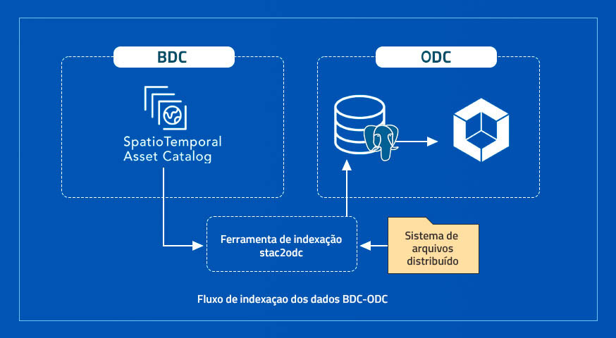
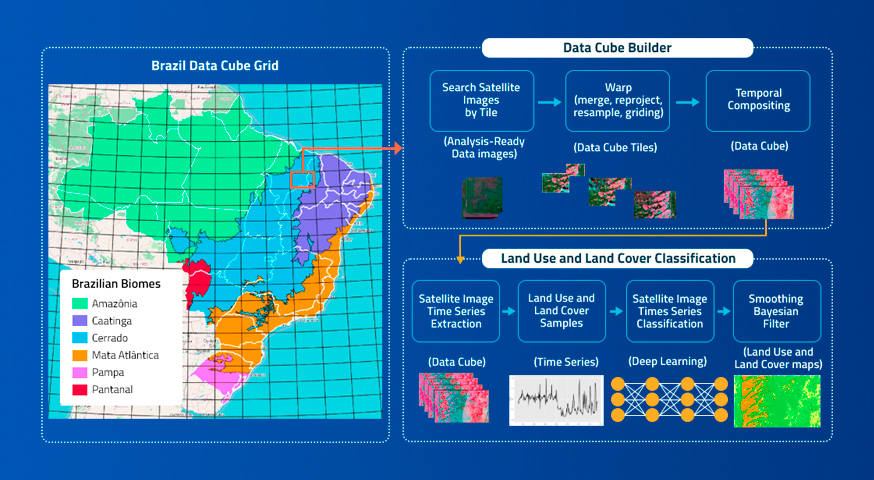
Earth Observation Data Cubes for Brazil: Requirements, Methodology and Products – En

by Karine R. Ferreira,Gilberto R. Queiroz,Lubia Vinhas,Rennan F. B. Marujo,Rolf E. O. Simoes,Michelle C. A. Picoli,Gilberto Camara,Ricardo Cartaxo,Vitor C. F. Gomes,Lorena A. Santos,Alber H. Sanchez,Jeferson S. Arcanjo,José Guilherme Fronza,Carlos Alberto Noronha,Raphael W. Costa,Matheus C. Zaglia,Fabiana Zioti,Thales S. Korting,Anderson R. Soares,Michel E. D. Chaves andLeila M. G. Fonseca Earth Observation and Geoinformatics Division, National Institute for Space Research …

Paper about the Brazil Data Cube Project

The article “Earth Observation Data Cubes for Brazil: Requirements, Methodology and Products” has been published in Remote Sensing Journal as part of the Special Issue State-of-the-Art Remote Sensing in South America and is available online at: https://www.mdpi.com/2072-4292/12/24/4033. See more publications of the Brazil Data Cube Project at https://data.inpe.br/bdc/papers/ Source: Brazil Data Cube Project

Brazil Data Cube team attends at Brazilian Symposium on Geoinformatics – GEOINFO 2020

The Brazil Data Cube (BDC) project team from the National Institute for Space Research (INPE) attended in XXI Brazilian Symposium on Geoinformatics – GEOINFO 2020. The event was held virtually, from November 30 to December 03, 2020. The GEOINFO series is an annual conference for exploring ongoing research, development and innovative applications on geographic information …

Integracão dos ambientes Brazil Data Cube e Open Data Cube

by Felipe Menino Carlos¹, Vitor C. F. Gomes², Gilberto Ribeiro de Queiroz¹,Karine Reis Ferreira¹, Rafael Santos¹ ¹Instituto Nacional de Pesquisas Espaciais (INPE) – 12227-010 – Sao José dos Campos – SP – Brasil ² Divisao de C4ISR – IEAV/DCTA – 12.228-001 – Sao José dos Campos – SP – Brasil Publisher: Anais do 21º GEOINFO | Published: …

Brazil Data Cube Cloud Coverage (BDC³) Viewer

by Felipe Rafael de Sá Menezes Lucena, Elton Vicente Escobar-Silva, Rennan deFreitas Bezerra Marujo, Matheus Cavassan Zaglia, Lubia Vinhas, Karine ReisFerreira and Gilberto Ribeiro de Queiroz Earth Observation and Geoinformatics Division, National Institute for Space Research(INPE), São José dos Campos – SP – 12227-010 – Brazil Publisher: Anais do 21º GEOINFO | Published: 3 December 2020 Abstract …

New publication from Brazil Data Cube project team

The BDC project team has just published a paper in the journal IEEE TRANSACTIONS ON GEOSCIENCE AND REMOTE SENSING, about a new segmentation method based on a superpixel approach, entitled “Simple Non-Linear Iterative Temporal Clustering” Access in https://ieeexplore.ieee.org/document/9258957 (For now as Early Access). To see others publications from BDC team access https://data.inpe.br/bdc/papers/. Source: Brazil Data …

An Overview of Platforms for Big Earth Observation Data Management and Analysis

by Vitor C. F. Gomes 1,2, Gilberto R. Queiroz 2 and Karine R. Ferreira 2 1C4ISR Division, Institute for Advanced Studies (IEAv), São José dos Campos, SP 12228-001, Brazil 2Image Processing Division, National Institute for Space Research (INPE), São José dos Campos, SP 12227-010, Brazil Remote Sens. 2020, 12(8), 1253; https://doi.org/10.3390/rs12081253 Publisher: mdpi | Published: 16 April 2020 (This article belongs to the Special …

Stmetrics: A Python Package for Satellite Image Time-Series Feature Extraction

by Anderson R. Soares¹; Hugo N. Bendini¹; Daiane V. Vaz¹; Tatiana D. T. Uehara¹; Alana K. Neves¹; Sarah Lechler²; Thales S. Körting¹; Leila M. G. Fonseca¹ ¹General Coordination of Earth Observation – OBT, Brazil’s National Institute for Space Research (INPE), São José dos Campos, SP, Brazil ²Institute for Geoinformatics, University of Muenster DOI: https://doi.org/10.1109/IGARSS39084.2020.9323346 Publisher: IEEE Explorer | Published: 2 Oct. 2020 Published in: IGARSS …

Recent Applications of Landsat 8/OLI and Sentinel-2/MSI for Land Use and Land Cover Mapping: A Systematic Review

by Michel E. D. Chaves *,Michelle C. A. Picoli and Ieda D. Sanches General Coordination of Earth Observation (OBT), Remote Sensing Division (DSR), National Institute for Space Research (INPE), Av. dos Astronautas, São José dos Campos 1758, Brazil Remote Sens. 2020, 12(18), 3062; https://doi.org/10.3390/rs12183062 Publisher: mdpi | Published: 18 September 2020 Abstract Recent applications of Landsat 8 Operational Land Imager (L8/OLI) and …

Brazil Data Cube - 2019 - 2025