Slide 1

Production, visualization and analysis of large volumes of remote sensing images modeled as multidimensional data cubes for the entire Brazilian territory.

The Brazil Data Cube Project team participated in WorCAP/2020 with a lecture and mini-course on Geoinformatics

Nas duas últimas semanas aconteceu o WorCAP 2020, evento do programa de Pós-Graduação em Computação Aplicada (CAP) do Instituto Nacional de Pesquisas Espaciais (INPE). A equipe do BDC se fez presente no evento, no dia 09 de setembro de 2020 com a apresentação “Projeto Brazil Data Cube e suas pesquisas em computação aplicada” e nos …

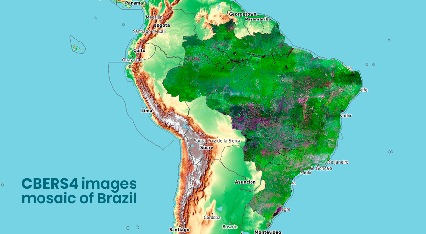
CBERS4 images mosaic of Brazil by the Brazil Data Cube Project

A CBERS4 image mosaic of Brazil was launched today by the Brazil Data Cube project team. This mosaic uses CBERS4/WFI images, surface reflectance, with 64 meters of spatial resolution. It was generated with technologies under development in the Brazil Data Cube project, using the best pixel (free from cloud and cloud shadows) chosen in a …

1st BDC Tech Talks – Open Data Cube: Introduction and Integration with the BDC project

Na última sexta-feira, 04 de setembro de 2020, a equipe do Brazil Data Cube realizou o 1º BDC Tech Talks. O Brazil Data Cube Tech Talks (BDC Tech Talks) é uma série de palestras internas hospedadas pela Equipe de Desenvolvimento do BDC, com hands-on, sobre temas ligados ao desenvolvimento de tecnologias utilizadas no nosso projeto. …

Two new publications from BDC project team

The proceedings of 2020 Latin American GRSS & ISPRS Remote Sensing Conference is available at IEEE Explore with two papers written by the Brazil Data Cube project team. The first paper describes the INPE’s initiatives in using remote sensing images and cloud services of the Amazon Web Services (AWS) infrastructure to improve land use and …

Virtual workshop Digital Earth Americas

Brazil, Mexico, Colombia and Chile presented today (August, 19) their initiatives and experiences in creating Earth observation data cubes in a virtual workshop about Digital Earth Americas organized by CEPAL, NASA and INEGI. The workshop attendees discussed visions for a solution that provides relevant Earth observation data for the benefit of the Americas. The Brazil …

Virtual hands-on training on the classification of time series of images

On August 12, 13 and 14, 2020, the Brazil Data Cube project team conducted a virtual hands-on training on the classification of remote sensing image time series using the R package for Satellite Image Time software package Series (SITS). The training was coordinated by Dr Gilberto Camara with support from the Brazil Data Cube (BDC) …

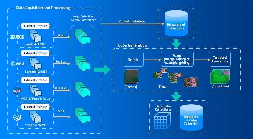
Using Remote Sensing Images and Cloud Services on Aws to Improve Land Use and Cover Monitoring

by K. R. Ferreira; G. R. Queiroz; G. Camara; R. C. M. Souza; L. Vinhas; R. F. B. Marujo; R. E. O. Simoes; C. A. F. Noronha; R. W. Costa; J. S. Arcanjo; V. C. F. Gomes; M. C. Zaglia Earth Observation and Geoinformatics Division, National Institute for Space Research (INPE), Avenida dos Astronautas, 1758, Jardim …

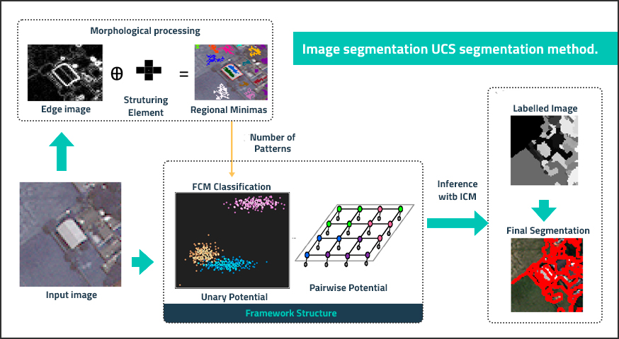
An Unsupervised Segmentation Method For Remote Sensing Imagery Based On Conditional Random Fields

by A. R. Soares; T. S. Körting; L. M. G. Fonseca; A. K. Neves Coordination of Earth Observation (OBT) – Brazil’s National Institute for Space Research (INPE) Av. dos Astronautas, São José dos Campos – SP, Brazil DOI: https://doi.org/10.1109/LAGIRS48042.2020.9165623 Publisher: IEEE | Published: 12 August 2020 Published in: 2020 IEEE Latin American GRSS & ISPRS Remote Sensing Conference (LAGIRS) …

Field Work – Luís Eduardo Magalhães/BA

Between July 20-24, 2020, collaborators of Brazil Data Cube Project carried out field work to collect samples in field to support project activities. Lucas Oldoni, doctoral student in Remote Sensing and José Guilherme Fronza, research associate of the project, master in Remote Sensing, both from Brazil’s National Institute for Space Research (INPE), traveled about 2904 …

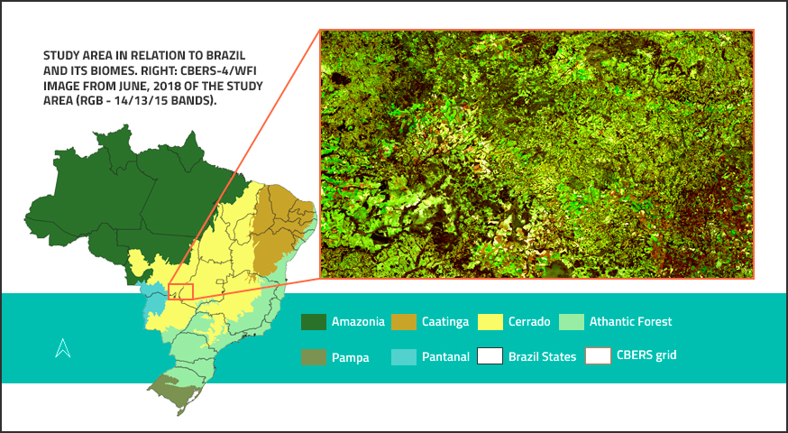
CBERS Data Cube: A powerful tecnology for mapping and monitoring brazilian biomes

by M. C. A. Picoli, R. Simoes, M. Chaves, L. A. Santos, A. Sanchez, A. Soares, I. D. Sanches, K. R. Ferreira, and G. R. Queiroz General Coordination of Earth Observation (OBT) – Brazil’s National Institute for Space Research (INPE), Av. dos Astronautas, 1758, São José dos Campos – SP, Brazil DOI: https://doi.org/10.5194/isprs-annals-V-3-2020-533-2020 Publisher: ISPRS | Published: …

Brazil Data Cube - 2019 - 2025