Slide 1

Production, visualization and analysis of large volumes of remote sensing images modeled as multidimensional data cubes for the entire Brazilian territory.

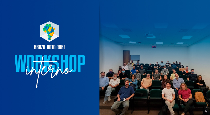
Internal Workshop of the Brazil Data Cube project

Last Friday, July 29, 2022, an internal workshop on the Brazil Data Cube project was held at INPE. The event was attended by 42 people, including the project team, partners, collaborators and master’s and doctoral students. In this workshop, the results, advances and partnerships with other INPE projects were presented and discussed, with the aim …

BDC team attended the IGARSS 2022 last week presenting one paper

The BDC team attended last week the International Geoscience and Remote Sensing Symposium (IGARSS 2022), presenting the paper “GENERATING ANALYSIS READY DATA COLLECTIONS FOR BRAZIL”. The paper presents the BDC Collection Builder: an application for Earth observation satellite images acquisition and processing to produce Analysis Ready Data. Access the poster here and the paper will be …

BDC in the conference “Using Big Data and Machine Learning for Land Cover and Land Use Mapping: Challenges to Mapping Accuracy”

The BDC team will present “Brazil Data Cube – Big Earth observation data modeled as multidimensional cubes, machine learning and image time series analysis” at the conference “Using Big Data and Machine Learning for Land Cover and Land Use Mapping: Challenges to Mapping Accuracy” to be held on July 5, 6 and 7, from 11:00h …

Sentinel-2 image Mosaic of Brazilian Paraiba State – 3 Months

by BDC Team National Institute for Space Research (INPE), Avenida dos Astronautas, 1758, Jardim da Granja, Sao Jose dos Campos, SP 12227-010, Brasil DOI – https://doi.org/10.52169/UAZM9531 Posted by Inpe | Published: May 2022 Overview An image mosaic of the Sentinel-2 images covering the Paraíba State in Brazil. It was created from a Sentinel-2 data cube, with …

Landsat Image Mosaic of Brazil – 6 Months

by BDC Team National Institute for Space Research (INPE), Avenida dos Astronautas, 1758, Jardim da Granja, Sao Jose dos Campos, SP 12227-010, Brasil DOI – https://doi.org/10.52169/VNFU3068 Posted by Inpe | Published: May 2022 Overview An image mosaic of the Landsat-8 images covering Brazil. It was created from a Landsat-8 data cube, with 30 meters of spatial …

CBERS-4A/WFI Image Mosaic of Brazil Paraíba State – 3 Months

by BDC Team National Institute for Space Research (INPE), Avenida dos Astronautas, 1758, Jardim da Granja, Sao Jose dos Campos, SP 12227-010, Brasil DOI – https://doi.org/10.52169/LTCE9643 Posted by Inpe | Published: May 2022 Overview An image mosaic of the CBERS-4A images covering the Paraíba State in Brazil. It was created from a CBERS-4A data cube, with …

CBERS-4/WFI Image Mosaic of Brazil – 3 Months

by BDC Team National Institute for Space Research (INPE), Avenida dos Astronautas, 1758, Jardim da Granja, Sao Jose dos Campos, SP 12227-010, Brasil DOI – https://doi.org/10.52169/HQWD4314 Posted by Inpe | Published: May 2022 Overview An image mosaic of the CBERS-4 images covering the Paraíba State in Brazil. It was created from a CBERS-4 data cube, with …

BDC team attended the XXIV ISPRS Congress 2022 last week presenting three papers

The BDC team attended the International Society for Photogrammetry and Remote Sensing Congress (XXIV ISPRS 2022), presenting three papers. The first paper “Building Earth Observation Data Cubes on AWS” describes an application for building EO data cubes on the Amazon Web Service (AWS) cloud computing environment. The second paper “Spatiotemporal Segmentation of Satellite Image Time …

Spatiotemporal segmentation of satellite image time series using self-organizing map

by B. L. C. Silva¹, F. C. Souza¹, K. R. Ferreira¹, G. R. Queiroz¹, and L. A. Santos¹ 1National Institute for Space Research (INPE), Brazil DOI: https://doi.org/10.5194/isprs-annals-V-3-2022-255-2022 Publisher: ISPRS | Published: 17 May 2022 © Author(s) 2022. This work is distributed under the Creative Commons Attribution 4.0 License. Abstract Nowadays, researchers have free access to an unprecedentedly …

An analysis of the influence of the number of observations in a random forest time series classification to map the forest and deforestation in the Brazilian Amazon

by L. S. Vieira¹, G. R. Queiroz¹, and E. H. Shiguemori² ¹Earth Observation and Geoinformatics Division, National Institute for Space Research, INPE, São José dos Campos 12227-010, Brazil²Surveillance and Reconnaissance Division, Institute for Advanced Studies, IEAv, São José dos Campos 12228-001, Brazil DOI: https://doi.org/10.5194/isprs-archives-XLIII-B3-2022-721-2022 Publisher: ISPRS | Published: 30 May 2022 © Author(s) 2022. This work …

Brazil Data Cube - 2019 - 2025