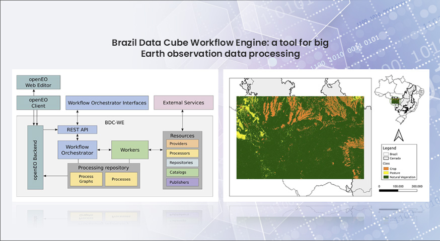
Slide 1

Production, visualization and analysis of large volumes of remote sensing images modeled as multidimensional data cubes for the entire Brazilian territory.

Use of time series for land use and land cover classifications in Petrolina, Pernambuco

by Pedro Brito 1 Michel Chaves 1 Herica Carvalho 2 Felipe Souza 1 Baggio Silva 1 Karine Ferreira 1 Rafael Santos 1 Gilberto Ribeiro de Queiroz 1 ¹ Instituto Nacional de Pesquisas Espaciais, Avenida dos Astronautas, 1758, Jardim da Granja, Sao Jose dos Campos, SP 12227-010, Brasil 2 Universidade Federal de Pernambuco – UFPE Anais / Proceedings XX SBSR – Vol 20, 2023. – …

Mapping of forest disturbances in the state of Maranhão using time series and data cubes

by Wesley Augusto Campanharo 1 Celso H. L. Silva-Junior 2 Mateus de Souza Macul 1 Karine Ferreira 1 Gilberto Ribeiro de Queiroz 1 ¹ National Institute for Space Research (INPE), Avenida dos Astronautas, 1758, Jardim da Granja, Sao Jose dos Campos, SP 12227-010, Brazil 2 University of California Los Angeles – UCLA Anais / Proceedings XX SBSR – Vol 20, 2023. …

DETER Intenso and Forest Monitor: Improving the alerting of deforestation in the Brazilian Amazon Rainforest

by Luis E. P. Maurano 1 Gilberto Ribeiro de Queiroz 1 Lúbia Vinhas ¹ Karine Ferreira 1 Claudio Aparecido de Almeida 1 Raphael Willian da Costa 1 ¹ National Institute for Space Research (INPE), Avenida dos Astronautas, 1758, Jardim da Granja, Sao Jose dos Campos, SP 12227-010, Brazil Anais / Proceedings XX SBSR – Vol 20, 2023. – 56460: https://proceedings.science/sbsr-2023/trabalhos/deter-intenso-and-forest-monitor-improving-the-alerting-of-deforestation-in-the?lang=pt-br Publisher: SBSR …

Brazil Data Cube team presented a mini-course at SBSR-2023

The Brazil Data Cube project team gave a mini-course on “Earth Observation Data Cubes and Time Series Analysis of Remote Sensing Images” at the 20th Brazilian Symposium on Remote Sensing (SBSR-2023) in Florianópolis, SC on April 2nd, 2023. The course, which lasted 8 hours, aimed to provide an introduction to the concepts of Earth observation …

Sentinel-2 image Mosaic of Brazilian Cerrado Biome – 4 Months

by BDC Team National Institute for Space Research (INPE), Avenida dos Astronautas, 1758, Jardim da Granja, Sao Jose dos Campos, SP 12227-010, Brasil DOI – https://doi.org/10.52169/BDWU9608 Posted by Inpe | Published: February 2022 Overview An image mosaic of the Sentinel-2 images covering the Cerrado Biome in Brazil. It was created from a Sentinel-2 data cube, with …

Four software systems developed in the Brazil Data Cube project were registered with the INPI (National Institute of Industrial Property)

The Brazil Data Cube team has just registered four software systems developed in the project with the National Institute of Industrial Property (INPI). The number of computational systems registered with INPI is one of the productivity indicators of the National Institute for Space Research (INPE) and its postgraduate courses. The registered systems are: (1) Web …

Using Earth Observation Data Cube to Mapping Burned Areas

by Mateus de Souza Macul¹, Wesley Campanharo¹, Fabiano Morelli¹, Gilberto Ribeiro de Queiroz¹, Karine Reis Ferreira¹ 1National Institute for Space Research (INPE), Brazil GeoInfo: http://mtc-m21d.sid.inpe.br/rep/8JMKD3MGP3W34T/488BPNL Publisher: GeoInfo | Published: 29 November 2022 © Author(s) 2022. This work is distributed under the Creative Commons Attribution 4.0 License. Abstract Earth observation data cubes are multidimensional structures created from Analysis-Ready …

Web Service for extracting Phenological Metrics for Agriculture using time series of satellite images

by Gabriel Kyama Alves¹, Karine R. Ferreira¹, Bruno Schultz, Thiago G. Rodrigues e Luiz F.R. Carvalho 1National Institute for Space Research (INPE), Brazil GeoInfo: http://mtc-m21d.sid.inpe.br/rep/8JMKD3MGP3W34T/488BPNL Publisher: GeoInfo | Published: 29 November 2022 © Author(s) 2022. This work is distributed under the Creative Commons Attribution 4.0 License. Abstract The study of seasonal vegetation patterns observed by remote sensing …

Integranting Analysis Methods During Land Use and Land Cover Sampling

by Abner Ernâni dos Anjos¹, Karine Reis Ferreira¹, Gilberto Ribeiro de Queiroz¹, Fabiana Zioti ¹, Gabriel Sansigolo¹ 1National Institute for Space Research (INPE), Brazil GeoInfo: http://mtc-m21d.sid.inpe.br/rep/8JMKD3MGP3W34T/488BPNL Publisher: GeoInfo | Published: 29 November 2022 © Author(s) 2022. This work is distributed under the Creative Commons Attribution 4.0 License. Abstract The Land Use and Land Cover (LULC) mapping …

Generating analysis ready data collections for Brazil

by Rennan F. B. Marujo¹, Karine R. Ferreira¹, Gilberto R. Queiroz¹, Raphael W. Costa¹, Jeferson S. Arcanjo¹, Ricardo C. M. Souza¹ National Institute for Space Research (INPE), Avenida dos Astronautas, 1758, Jardim da Granja, Sao Jose dos Campos, SP 12227-010, Brazil DOI: https://doi.org/10.1109/IGARSS46834.2022.9884104 Publisher: IEEE  | 28 September 2022 Abstract Brazil is a country of continental scale area, …

Brazil Data Cube - 2019 - 2025