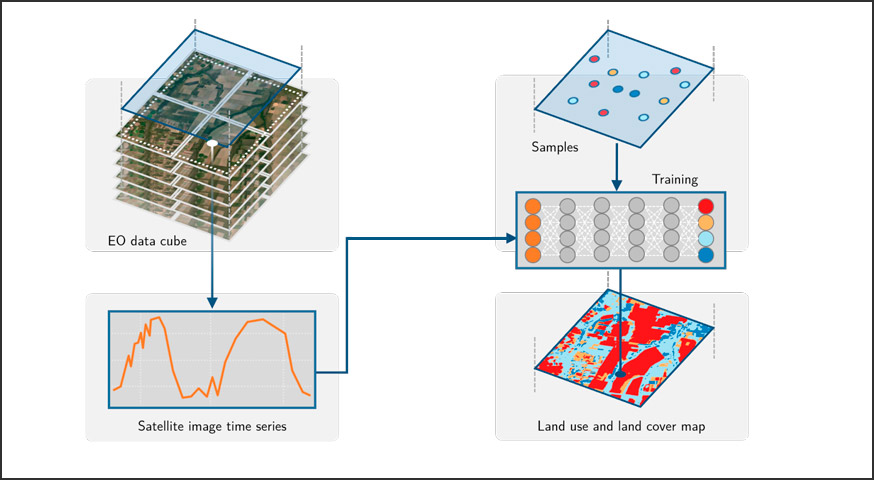

Sits package is an open source software for analysis, visualization and classification of satellite image time series data.
Sits has been designed to work with big satellite image data sets and to fully support all steps of land use and land cover classification workflow, including but not limited to: sampling selection, time series clustering, machine learning model training and validation, classification, and maps post-processing.

SITS – Satellite Image Time Series
Sits puts together a set of tools for analysis and classification of time series such as self-organized maps clustering, filtering, and data visualization. Also, it provides the most advanced machine learning algorithms to generate land use and land cover maps based on satellite image time series. Some of the machine learning methods available in sits are: Support Vector Machine, Random Forests, Extreme Gradient Boosting, 1D fully connected Multi-layer Perceptrons, 1D Convolutional Neural Networks, and 1D version of ResNet method.

Associated publications:
by Rolf Simoes 1 , Gilberto Camara 1, Gilberto Queiroz 1, Felipe Souza 1, Pedro R. Andrade 1, Lorena Santos 1, Alexandre Carvalho 2 and Karine Ferreira 1 1National Institute for Space Research (INPE), Avenida dos Astronautas, 1758, Jardim da Granja, Sao Jose dos Campos, SP 12227-010, Brazil 2National Institute for Applied Economics Research, SBS, Quadra 1 Bloco J, Brasília, DF 70076-900, Brazil Remote Sens. 2021, 13(13), …
Continue reading “Satellite Image Time Series Analysis for Big Earth Observation Data”
by Lorena Alves Santos 1,*,Karine Ferreira 1,Michelle Picoli 1,Gilberto Camara 1, and Rolf E. O. Simoes¹ 1Earth Observation and Geoinformatics Division, National Institute for Space Research (INPE), Avenida dos Astronautas, 1758, Jardim da Granja, Sao Jose dos Campos, SP 12227-010, Brazil DOI: https://doi.org/10.1016/j.isprsjprs.2021.04.014 Publisher: ScienceDirect | Published: 15 May 2021 Abstract The extensive amount of Earth observation satellite images available brings opportunities …
Continue reading “Quality control and class noise reduction of satellite image time series”


