
A Scalable Clustering-Based Method for Vegetation Mapping in Large Areas Using Satellite Image Time Series
by Baggio Luiz de Castro e Silva1, Karine Reis Ferreira1, Gilberto Ribeiro de Queiroz1, Juliana Santos da Mota1, Erison C. S. Monteiro1, Mayara Teodoro1, Isabel Cristina de Oliveira Silva1, Murilo Brasil da Silva1, Rodrigo Delgado Inácio1, Rafael Andrade Aluvei1, Agata Fabielle Gomes, Claudio Almeida1 and Marcos Adami1
1National Institute for Space Research (INPE)
Big Earth Data: https://www.tandfonline.com/journals/tbed20
Publisher: MDPI | Published in 3 July 2022
Abstract
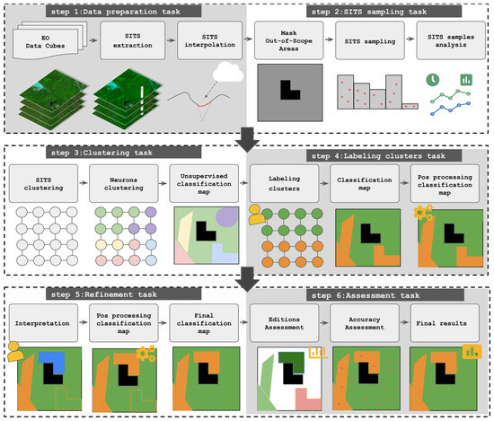
The Brazilian Cerrado, a global biodiversity hotspot, is under increasing pressure from agricultural expansion and native vegetation conversion, underscoring the need for efficient monitoring to support conservation and environmental policies. In heterogeneous landscapes, land use and land cover (LULC) mapping using supervised classification methods faces a major bottleneck: the need for extensive and high-quality training datasets. To address this challenge, we propose a semi-automated, clustering-based methodology for mapping secondary vegetation within previously deforested areas, reducing training-sample requirements and enabling scalable mapping through the clustering of satellite image time series. In the first stage, an unsupervised process integrates graphics processing unit (GPU)-accelerated Self-Organizing Maps and hierarchical clustering with Dynamic Time Warping to produce spectro-temporal clusters. In the second stage, specialists label and refine these clusters by visual interpretation, transferring expert knowledge from individual pixels to grouped spectro-temporal patterns. Applied to 692,000 km2 of previously deforested land in the Cerrado biome, the methodology produced a mapped secondary vegetation area of 81,209 km2 (11.74%). The design-based estimated area was 98,683 ± 10,071 km2, with an overall accuracy of 96.45 ± 1.52%, a user’s accuracy of 96.27 ± 2.40%, a producer’s accuracy of 79.22 ± 7.94%, and an F1-score of 86.90%. The initial cluster labeling accounted for 86.3% of the final secondary vegetation area and limited the interpretation task to approximately 3000 cluster-level decisions. Implemented in the TerraClass Cerrado 2024 cycle, the workflow reduced the secondary vegetation mapping phase from approximately two years to six months while maintaining the thematic accuracy required for large-scale operational monitoring.
Keywords: self-organizing maps; secondary vegetation; brazilian cerrado biome; deforested areas; unsupervised classification; sentinel-2 image time series.
Share and Cite
Silva, B.L.d.C.e.; Ferreira, K.R.; Queiroz, G.R.d.; da Mota, J.S.; Monteiro, E.C.S.; Teodoro, M.; de Oliveira Silva, I.C.; Silva, M.B.d.; Inácio, R.D.; Aluvei, R.A.; et al. A Scalable Clustering-Based Method for Vegetation Mapping in Large Areas Using Satellite Image Time Series. Remote Sens. 2026, 18, 2162. https://doi.org/10.3390/rs18132162.