Slide 1

Production, visualization and analysis of large volumes of remote sensing images modeled as multidimensional data cubes for the entire Brazilian territory.

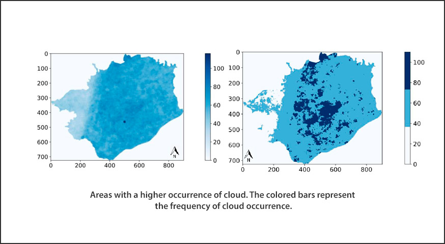
Automated cloud coverage analysis with Brazil Data Cube

by Thainara Lima¹, Rômulo Marques ¹, Ueslei Sutil¹, Cláudia Almeida¹, Claudio Barbosa¹, Thales Körting¹, Gilberto Queiroz¹ ¹Instituto Nacional de Pesquisas Espaciais Avenida dos Astronautas, Jardim da Granja,São José dos Campos, SP, Brazil, CEP 12227010 Publisher: Anais do 22º GEOINFO | Published: 2 December 2021 Abstract This paper approaches the topic of Data Cubes applied to the management …

Utilizando o padrão SpatioTemporal Asset Catalog para visualização de dados.

by Thais de Medeiros¹, Bruno dos Santos¹, Gilberto Oliveira¹, Thales Korting², Gilberto de Queiroz² ¹Programa de Pós Graduação em Sensoriamento Remoto – Instituto Nacional de Pesquisas Espaciais (INPE) – São José dos Campos, SP – Brasil ²Divisão de Observação da Terra e Geoinformática – Instituto naional de Pesquisas Espaciai (INPE) – São José dos Campos, SP …

The BDC team presents the results in using the AWS computing environment to process big Earth observation data

The BDC team will present the results in using the AWS computing environment to process big Earth observation data in the session “Share lessons learned from the effort to democratize access to Earth Observations and computing environments for developing countries in support of sustainable development” in the GEO-AWS EO Cloud Credits side-event of the GEO …

Simple Non-linear Iterative Temporal Clustering

by Anderson Soares¹;  Thales Körting¹;  Leila Fonseca¹;  Hugo Bendini¹ 1Earth Observation and Geoinformatics Division, National Institute for Space Research (INPE), Avenida dos Astronautas, 1758, Jardim da Granja, Sao Jose dos Campos, SP 12227-010, Brazil DOI: https://doi.org/10.1109/TGRS.2020.3033266 Publisher: IEEE  | Published: 16 November 2020 Published in: IEEE Transactions on Geoscience and Remote Sensing ( Volume: 59, Issue: 9, Sept. 2021) Abstract Classifying …

Presentation today on the BDC project at the 6th Scientific Day of Geography UNIFAL-MG.

O projeto BDC será apresentado hoje, 10 de novembro, às 19:00, na mesa redonda sobre “Avanços geotecnológicos como suporte à análise geográfica”. O evento terá transmissão via canal do youtube do Programa de Pós-Graduação em Geografia (PPGEO/UNIFAL). Neste ano, a 6ª Jornada Científica da Geografia terá como tema “O conhecimento geográfico na interpretação do mundo …

Integrating Open Data Cube and Brazil Data Cube Platforms for Land Use and Cover Classifications

by Felipe Menino Carlos¹, Vitor Conrado Faria Gomes², Gilberto Ribeiro de Queiroz¹, Felipe Carvalho de Souza¹, Karine Reis Ferreira¹ and Rafael Santos¹ 1National Institute for Space Research (INPE), Earth Observation and Geoinformatics Division, São José dos Campos –SP, Brazil. ²Institute for Advanced Studies (IEAv), C4ISR Division, São Josédos Campos –SP, Brazil. vitorvcfg@fab.mil.br. DOI: http://dx.doi.org/10.14393/rbcv73n4-60387 Publisher: Revista Brasileira …

Rstac: An R Package to Access Spatiotemporal Asset Catalog Satellite Imagery

by Rolf Simoes¹; Felipe Carvalho de Souza¹; Matheus Zaglia¹; Gilberto Ribeiro de Queiroz¹; Rafael D. C. dos Santos¹; Karine Reis Ferreira¹ 1Earth Observation and Geoinformatics Division, National Institute for Space Research (INPE), Avenida dos Astronautas, 1758, Jardim da Granja, Sao Jose dos Campos, SP 12227-010, Brazil DOI: https://doi.org/10.1109/IGARSS47720.2021.9553518 Publisher: IEEE  | 12 October 2021 Published in: 2021 IEEE International Geoscience and Remote Sensing …

Assessing Satellite Image Time Series Clustering Using Growing SOM

by Rodrigo de Sales da Silva Adeu, Karine Reis Ferreira, Pedro R. Andrade, Lorena Santos National Institute for Space Research (INPE) – São José dos Campos, Brazil DOI: https://doi.org/10.1007/978-3-030-58814-4_19 Publisher: Springer Link | Published: 03 October 2020 Part of the Lecture Notes in Computer Science book series (LNCS, volume 12253) Abstract Mapping Earth land use and cover changes is …

CBERS data cubes for land use and land cover mapping in the Brazilian Cerrado agricultural belt

by Michel E. D. Chaves, Anderson R. Soares, Ieda D. Sanches and José G. Fronza Earth Observation and Geoinformatics Division, National Institute for Space Research (INPE), Avenida dos Astronautas, 1758, Jardim da Granja, Sao Jose dos Campos, SP 12227-010, Brazil DOI: https://doi.org/10.1080/01431161.2021.1978584 Publisher: International Journal of Remote Sensing | Published: 30 Sep 2021 Abstract The agricultural frontier expansion …

BDC team will attend FOSS4G 2021’s Indigenous Hackathon by GEO

On October 1-2, 2021, the BDC team will attend the Indigenous Hackathon by the Group on Earth Observations (GEO). A hackathon by and for Indigenous communities, at FOSS4G (Free and Open Source Software for Geospatial) 2021 conference. The FOSS4G conference is the premier international event dedicated to presenting new developments in open-source software for geospatial …

Brazil Data Cube - 2019 - 2025